Call NOW 02 6681 4054
- Home
- Bikes
- Scooters
- Accessories
- Helmets
- Clothing
- Shoes
- Parts
- Tyres
- CLEARANCE
- Where We Ride
- Brands
- Custom, Classic & Vintage Builds
Your cart is currently empty
Product image slideshow Items
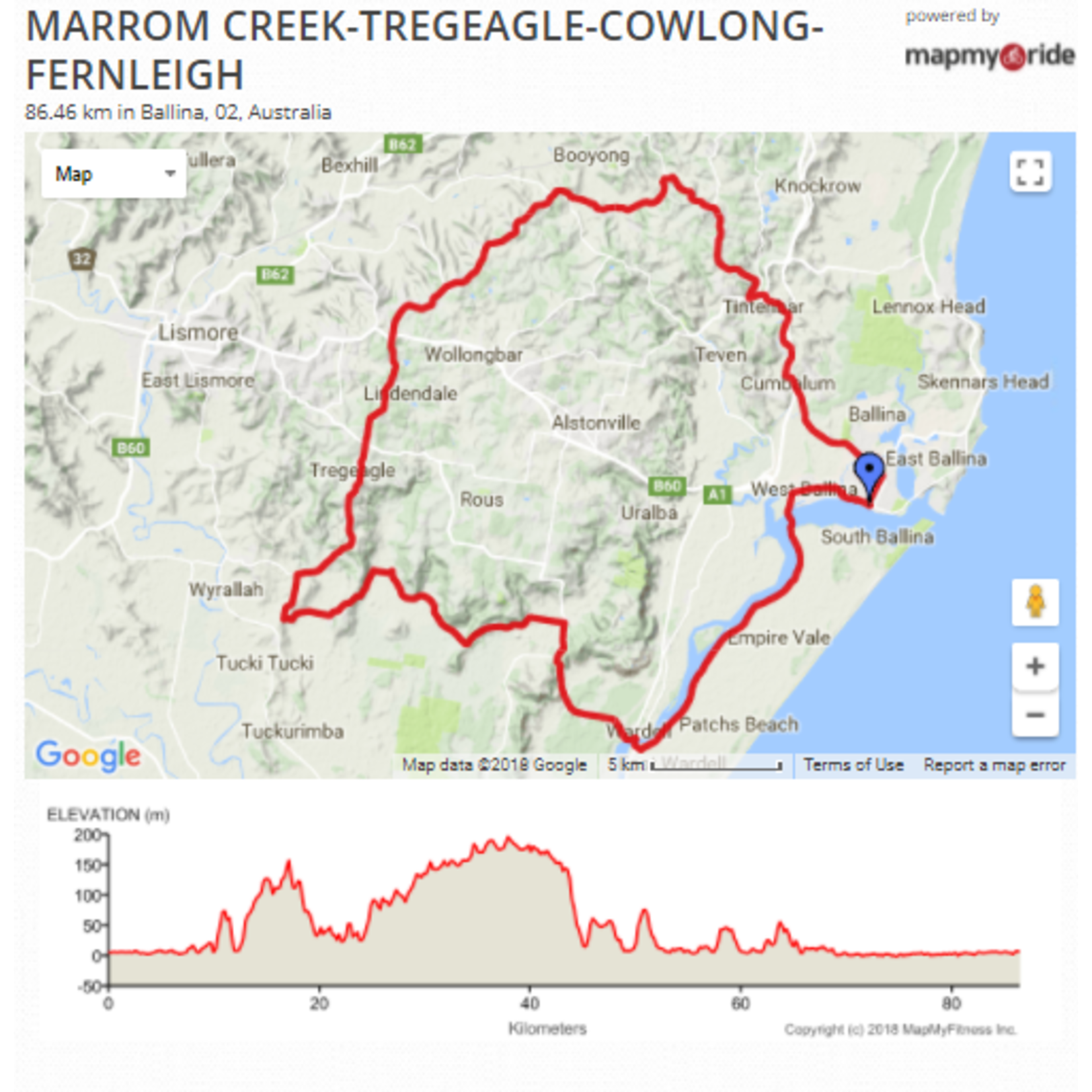
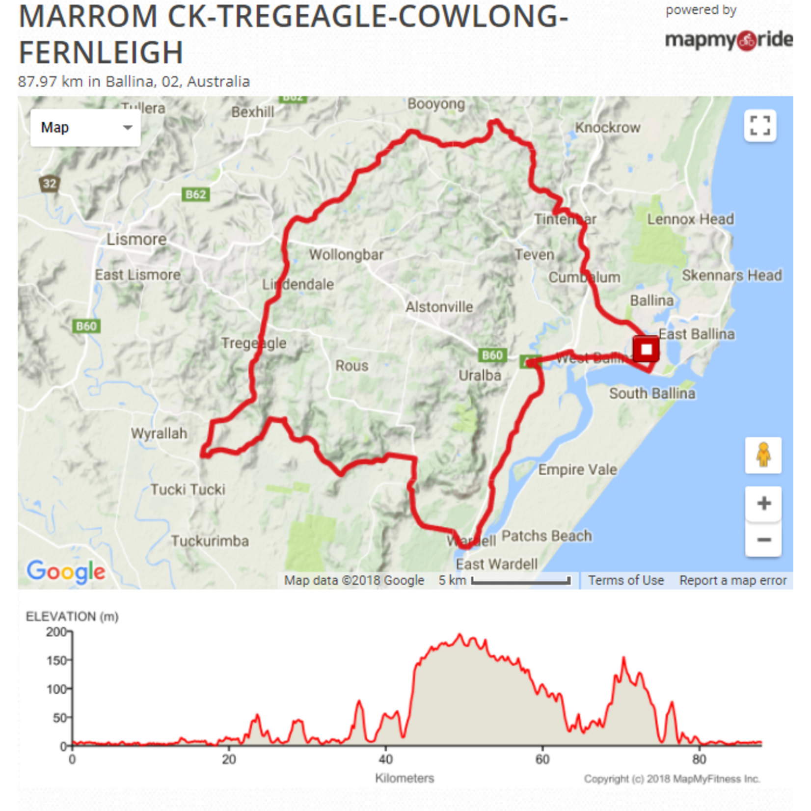

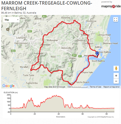
A GREAT RIDE in either direction - clockwise for a brutal Cat 4 climb and anti-clockwise for one of the best descents in the area! Total distance about 86km with almost 950m of climbing.
Clockwise: head west out of town and take the motorway on-ramp heading south, cross the bridges over Emigrant Creek and then left into Pimlico Rd and follow that to Wardell. At the Wardell Pub turn left then right under the bridge and road becomes the Alstonville-Wardell Rd. Follow that over the Ballina to Woolgoolga Bypass, and a couple of rollers, down the other side and continue to the Marom Creek Hall on the left and turn left into Marom Creek Rd.
Follow that to a rough T intersection; right goes up Devil's Elbow, so turn left over the bridge and at the next T intersection left up Tucki Hills. At the top of the 2nd climb turn right into Robson Rd then right again onto Tregeagle Rd. A small descent over the creek and then the climb starts! (you can cut out part of the climb by turning right at the top of the first Tucki Hill into Grennan Rd - but you didn't hear it from me). Grennan Rd also has a section of gravel about 1km ling.
At the top of Tregeagle Rd there is an crossroads and an old wooden church ahead on the right. Keep going past the church till you get to another old church, was a cafe - The Spotted Pig.
Cross the Bruxner Highway here and follow Cowlong Rd to the end (the last section is actually Pearson Rd). At the end turn right onto Eltham Rd and then left into Houghlahans Creek Rd. Follow that along the flats and take a left into Tooheys Mill Rd. At a Y intersection veer right into Nashua Rd. Over the top of that climb the road veers left and over a little rise to a T intersection at Fernleigh Rd.
Turn right into Fernleigh (or left to add Newrybar - Old Byron Bay Rd - Knockrow), down Fernleigh Rd to the end; left past the Tintenbar shops, right at the top of the hill, up a bit further then a flying descent on the old highway, Tamarind Drive (and a Strava segment) and follow that back into town.
Clockwise:
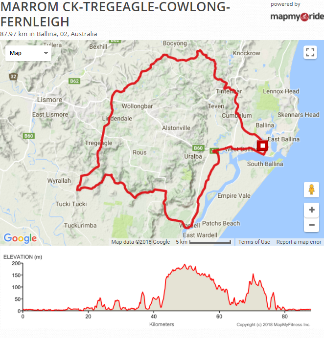
Counter-Clockwise